Welcome to the Pineywoods Ecosystems Gallery! (Version 20.09
These galleries explore the local ecosystem types of "Pineywoods"-the forested eastern edge of Texas and the the ecologically-similar forests of adjacent Louisiana. Markedly different from most of Texas, tall stands of trees cover much of the gently rolling landscape. There is a rich variety of natural habitats: Upland pine-oak communities, remnants of once-extensive longleaf pine woodlands, rich "mesic" deciduous forests on sheltered slopes and along small streams, and vast "bottomland hardwood" forests on the floodplains of the region's numerous rivers. The climate is warm and humid; some areas experience as much as 50" (1270 mm) of rainfall a year. Timber, poultry, oil and gas extraction and ranching are among the important local industries and much of the Pineywoods remains relatively free from urbanization. Public lands such as Kisatchie National Forest (Louisiana), the National Forests & Grasslands of Texas the Big Thicket National Preserve and the Pineywoods Native Plant Center on the campus of Stephen F. Austin State University in Nacogdoches, TX, enable one to easily explore the rich and varied natural environment.
We provide images of both local ecosystems and the plants typically found in them. They reflect the characteristic natural or near-natural (usually forested) plant assemblages which develop in an ecosystem over time in the absence of extensive human disturbance and only touch on high-disturbance ecosystems. However, vegetation in a location is a function of both natural environmental factors (soils, topography, and climate) and any management or disturbance a site has experienced; the plant communities on disturbed or heavily managed sites may be rather different from the "potential natural" communities described here.
Our aim is to reconnect students, laymen, and professionals with the plants and ecosystems that form the foundation of both the ecology and economy of east Texas. We hope you enjoy this window into the natural world of this fascinating, and to many, little known, part of North America.
The Three Pineywoods Landscapes
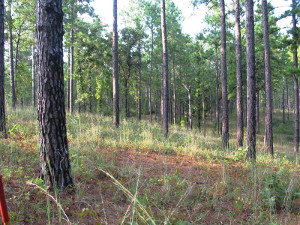
Pine-dominated, mixed-forest, or ruderal uplands typically occur on mid to upper slopes, ridgetops, and on broad, rolling upland interfluves. Most natural plant communities are dominated either by pines or by a mixture of pines and deciduous angiosperm (hardwood) trees. Occasionally, forests largely composed of upland oak species and hickories many occur. Rarely, extreme soil conditions (usually heavy clay, glauconitic sandstone outcrops, or saline soils) result in natural oppenings in the forest. Pine-dominated uplands are the main landscape in most locales. Many have had significant human impact; these support disturbed, early-seral, or altered (ruderal) plant communities.
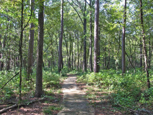
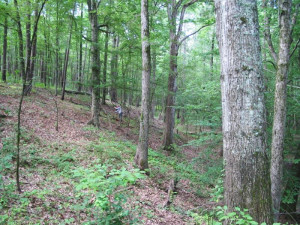
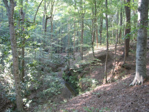
Mesic slopes, ravines, terraces, and stream bottoms occur on the lower portions of the major slopes that lead down to rivers and streams, in the valleys and ravines of small streams, and on higher, non-flooded terraces adjacent to stream and river floodplains. They typically enjoy higher soil moisture and nutrient levels than pine-dominated uplands, were historically sheltered from fire, and natural stands usually consist of deciduous hardwoods often with scattered loblolly pines. Of all local habitat types, these forests show the closest affinity to the temperate deciduous forests of the Midwestern and northeastern US.
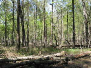
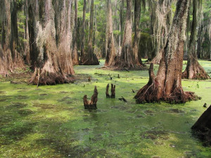
River floodplains & swamps, the third principal Pineywoods landscape, are the broad, flat floodplains of the larger streams, bayous, and rivers that wind through the Pineywoods. Flood-tolerant deciduous trees ("bottomland hardwoods") dominate most natural floodplains while baldcypress occupies the deepest swamps. In the south and east of the region, water tupello often co-occurs with baldcypress.
The Galleries
Each gallery provides both landscape scenes of the ecosystem type and images of the plants typically found there. One can recognize three categories of species when describing a habitat type: 1) indicator species: species which are statistically associated with habitat differences accross a data set representing the range of ecosytem types and achieve their maximum abundnace and frequency in the given ecosystem type but are less frequent, rare, or absent from others. The presence of such a species is an excellent indicator of ecosystem type. 2) characteristic species: Species that are usually present (>40% of the time for most of our galleries) and often commonin a given ecological type but are more frequent and common in at least one other other ecosystem type. The presence of such species do not alone indicate the ecosystem type but in combination with other plants they provide a good indication of the habitat. 3) Rare and unusual species: Species that occurr too sporadically to be statistically associated with habitat differences but are nearly always observed on the given ecossytem type; these are often of conservation concern. All three types of species appear in the galleries.
What's New
- 27 August 2020: Version 20.09. Gave the pages a new look, cleaned up some of the html, and revised the nomenclature for certain plant names; revisions and corrections focussed the Eudicots and were in parallel with the writing of Part 1 (Eudicotyledons, Magnoliids & Nymphaeiids) of a new flora manual for the region entitled "Plants of the Pineywoods of east Texas and west Louisiana". In addition to being a local flora, it includes detailed descriptions of the vegetation & environment of our ecosystems. Illustrated by local artist Bruce Lyndon Cunningham (forester-artist.com) we expect publication (Bruce Lybdon Cunningham Productions, Nacogdoches, TX) sometime in 2021!
- 26 October 2017. Version 17.10. A complete re-compilation of the galleries: Inclusion of a species is now largely based on statistical analyis of sample plots. Galleries are derived from multivariate classification (mainly TWINSPAN and flexible B cluster analysis) of field data from 680 forest stands from throughout the Pineywoods followed by indicator species analysis (ISA) of the resulting groups inorder to generate lists of species statistically associated with differences among the groups. Maintenence revision 10/02/18 (ver. 17.10.1).
- 26 October 2017: Version 17.10 (2002-2017). After going 'dark' following the loss of our server 'src.sfasu.edu' we are back with the 15th Aniversary Edition of Pineywoods Plants! Please update links & bookmarks to the new address as it is uncertain how long the redirect will last. For this edition we've added 670 new images including 18 new species.
- 10 June 2010 (Version 10.06): A new ecosystem (high flood-energy streambanks) was added and several corrections were made as part of a major revision of the parent Pineywoods Plants gallery.
- 10 April 2014: Version 14.04. A minor update with several corrections and the net addition 262 images.
- 13 May, 2008 (Version 8.05): The Pineywoods Ecosystems gallery was launched as a part of revisions to its parent gallery "Pineywoods Plants" which consists of photographs of plants from far east Texas.